Walk, Hike, & Bike Around Homer & Kachemak Bay
Trail Descriptions
Trails in Homer and Kachemak Bay State Park range from family-friendly to difficult and occasionally impassable; check the current trail conditions at www.alaskastatetrails.org. For more information about trails, camping, and water availability, visit alaskastateparks.org. When accessing trailheads from the water, look for a triangular orange sign with a black T on it marking the location of the trailhead.
Homer Area
1. DIAMOND CREEK TRAIL 4.2 MI (MODERATE)
Popular for birding, hiking, and running, this 4.2-mile out-and-back trail takes you through tall grass meadows and alder forests before dropping to the Cook Inlet beach. The trail's upper half is primarily switchbacks with a crushed-rock surface, with some areas of clay that can be slick if wet. The trail's last section is quite steep. A walking stick is a good idea. At the bottom, you're about halfway between the mouth of the Anchor River and Bishop's Beach (about 15 miles in either direction). The shore along this stretch is quite shallow. At low tide, a large portion of the beach is exposed, along with interesting creatures like sea stars, anemones, crabs, and sometimes octopuses! Keep an eye out for eagles, sea otters, other sea birds, and even whales! Remember to check tides; rising tides can trap you against the bluffs. The trail may be closed due to trail conditions.
2. BAYCREST TRAIL/HOMESTEAD TRAIL LOOP 3.6 MI (MODERATE)
Roger’s Loop to Diamond Ridge Road, roughly 7 miles round trip. Trailheads can be accessed on both Roger’s Loop and Diamond Ridge Road. Hike through woods, grassy fields, and some hills or, in the winter, cross-country ski amazing groomed trails. The portion of the Homestead Trail between Diamond Ridge Road and the reservoir is overgrown and not marked so it is not shown on this map.
3. REBER TRAIL 0.4 MI (MODERATE)
Located off of West Hill in Homer, this o.4-mile trail offers stunning views of Kachemak Bay from an overlook that switchbacks down through amazing wildflowers and streams. Watch for moose.
4. PRATT MUSEUM FOREST TRAIL 0.4 MI (EASY)
Conveniently located in downtown Homer right behind the Pratt Museum & Park, the trail is open year-round and beautiful to visit anytime. The museum often provides educational recreation opportunities for visitors and residents, especially families and children.
5. BELUGA SLOUGH TRAIL 0.6 MI (EASY)
This 1.2-mile loop trail in Homer is great for hiking and walking and is wheelchair accessible. Depending on the time of year, you may see sandhill cranes, seagulls, and mottled sandpipers. You’ll also enjoy wildflowers such as fireweed and lupine and many water grasses.
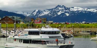
6. HOMER SPIT TRAIL 4.3 MI (EASY)
Start at the base of the Homer Spit for this 4.3-mile paved trail to the tip of the Spit. Along the way, you will pass the Nick Dudiak Fishing Lagoon (the fishing hole), the Homer Boat Harbor, and many boardwalk shops. This trail is perfect for walking or biking.
7. CALVIN & COYLE TRAIL 1.2 MI (EASY)
An approximately 1.2-mile loop with flat terrain through woods and meadows. A platform overlooking the Beluga Wetlands is a hot spot for bird watching. Watch for moose. Parking is available at the end of Mariner Drive.
8. HOMER BIKE TRAIL 5 MI (EASY)
The broad paved path starts at the corner of Lake Street and East End Road. Approximately 5 miles with flat terrain, perfect for walking or biking. Shops, coffee stands, and eateries are along the way.
9. WYNN NATURE CENTER LUTZ/FIREWEED & DOGWOOD TRAILS LOOP 1.4 MI EASY)
This 1.4-mile loop is popular for birding, hiking, and walking. It offers thick fauna, wildflowers, wildlife viewing, and bird watching. Keep an eye out for moose. Guided and unguided hikes are available. Handicapped accessible boardwalk and trail for the visually impaired.
10. MCNEIL CANYON LOOP 4.6 MI (MODERATE)
The 4.6-mile loop trail out of East End Road in Homer begins at McNeil Canyon Elementary School and is popular in the winter for cross-country skiing. Depending on the time of the year, it can be muddy and boggy in parts, but the views are breathtaking. Enjoy multi-glacial views as well as the rolling hills north of Homer. Keep an eye out for moose.
11. EVELINE STATE RECREATION / ALPINE MEADOW TRAIL 1.4 MI (EASY)
Explore this 1.4-mile loop trail out East End Road in Homer. The trail is surrounded by beautiful grasses, wildflowers, and a partial forest. You also can enjoy a view of two glaciers. The drive out East End is stunning and gives a different perspective of the Homer area. Look for a brown recreational area sign.
Kachemak Bay State Park
12. HUMPY CREEK TRAILHEAD 5.2 MI (EASY TO MODERATE)
Great trail to a beautiful salmon stream. Start at Glacier Spit. Take the Grewingk Tram Spur Trail to the tram. The tram may require 2 people to operate, max wt. 500 lbs. Turn left and follow a trail past blue pools of water to Humpy Creek. Practice bear awareness as black bears frequent the mouth of Humpy Creek when the salmon are spawning (July and August).
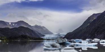
13. GLACIER LAKE TRAIL 3.2 MI (EASY)
By far the most popular day hike in Kachemak Bay State Park, this easy trail takes you to Grewingk Glacier Lake—very little elevation gain. Walk in the path of the receding glacier through a boreal forest out to the glacial moraine. Follow trails to a lake filled with ancient ice. Enjoy spectacular views. You can see and hear the glacier calving. Hikers most often return via the Saddle Trail.
14. SADDLE TRAIL 1 MI (MODERATE)
This popular trail, which begins at Halibut Cove and connects with Glacier Lake Trail, offers multiple switchbacks up and over a forested ridge. Many hikers take the Grewingk Glacier Lake Trail, enjoy the lake and take the Saddle Trail to Halibut Cove for a water taxi pickup at the end of their day.
15. ALPINE RIDGE TRAIL 2.5 MI (MODERATE TO DIFFICULT)
For awe-inspiring views head south at the top of Saddle Trail. This popular, quick route to alpine areas follows a ridge through spruce and alder to alpine tundra. Locals call this the “stairway to heaven.” Once you climb above the tree line and are in the alpine, the trail disappears. Meander across the open alpine; take in the sights and maybe a few blueberries if the season is right. Don’t forget your camera.
16. COALITION TRAIL 5.5 MI (MODERATE)
Coalition Trail connects China Poot Bay with Halibut Cove Lagoon and China Poot Lake Trail. The trail climbs over a low ridge, opening to scenic views of China Poot Bay. Next, hikers descend to China Poot Bay where they can get picked up by water taxi or continue south.
17. POOT PEAK TRAIL 4.6 MI (VERY DIFFICULT)
The north route (1.9 miles) climbs after the Wosnesenski River Trail junction. The steep, slick, unmaintained route climbs rapidly through the spruce first, alders, and loose scree slopes. The Summit Spur (1.1 miles from trailhead) leads to the peak, climbing very steeply for the next 0.2 miles to a rocky bench, or “Lower Summit” (2100’). This is a good stop for those unprepared to summit. CAUTION: Only climbers with rock climbing training should continue beyond this point. Climbing the 2600’ peak is hazardous due to shifting scree and rock. Hand and foot holds are poor at best and worse when wet. The rewards above the treeline include superb views of Wosnesenski Glacier and Kachemak Bay.
18. WOSNESENSKI RIVER TRAIL 11.3 MI (SOMEWHAT DIFFICULT)
Beginning from the Poot Peak Trail, this route winds through forests, meadows and bogs, up and over a low ridge, and into the Wosnesenski River Valley. The Wosnesenski River is a glacial river, braided with gravel flats on either side with sweeping vistas of mountains and glaciers and a spectacular 600’ waterfall.
19. SADIE KNOB TRAIL 6.3 MI (MODERATE, DIFFICULT IN PLACES)
This trail accesses an alpine ridge between Sadie Cove and Kachemak Bay. The north and south routes connect the north and south ends of Eldred Passage, both joining the ridge route. The trail follows the ridgeline to Sadie Knob where hikers can enjoy superb and expansive 360° views of Kachemak Bay. Watch for mountain goats, black bears, and eagles.
20. GRACE RIDGE TRAIL 8.2 MI (MODERATE TO DIFFICULT)
This trail begins at Kayak Beach Campsite and follows an old road that is now dense with alders. Next, hikers climb through old-growth Sitka spruce into stunning alpine. This hike offers dramatic views of Eldred Passage, Sadie Peak, Cook Inlet volcanoes, and beyond. Depending on the time of year, enjoy fresh blueberries along the way. Watch for mountain goats, black bears, and golden and bald eagles.